Okay so I got this idea a few months back - wanted to make this super clear map showing exactly how the First Crusade marched across Europe and into the Holy Land. Sounds simple, right? Like, just draw some lines on a map? Yeah, no. Let me tell you how it actually went down.
Why I Even Started This Mess
Honestly, saw a bunch of maps online and in books, but man, they were either way too complicated with a billion arrows or so simple they skipped half the important stops. Figured I could do it better, step-by-step. You know, show folks where they gathered, where they split, where they fought big battles, the whole journey. Decided I'd do it digital - thought it'd be easier. Used a basic online map tool I found.
The Grind Begins: Points & Lines Everywhere
First thing, I tried to just dump everything on at once. Big mistake. Pins for Cologne, for Clermont (where the Pope gave his speech), for Constantinople, Nicea, Antioch, Jerusalem... threw 'em all up there. Looked like a toddler stuck pins randomly in my dad's atlas. Zero sense of direction or timing. Total chaos.
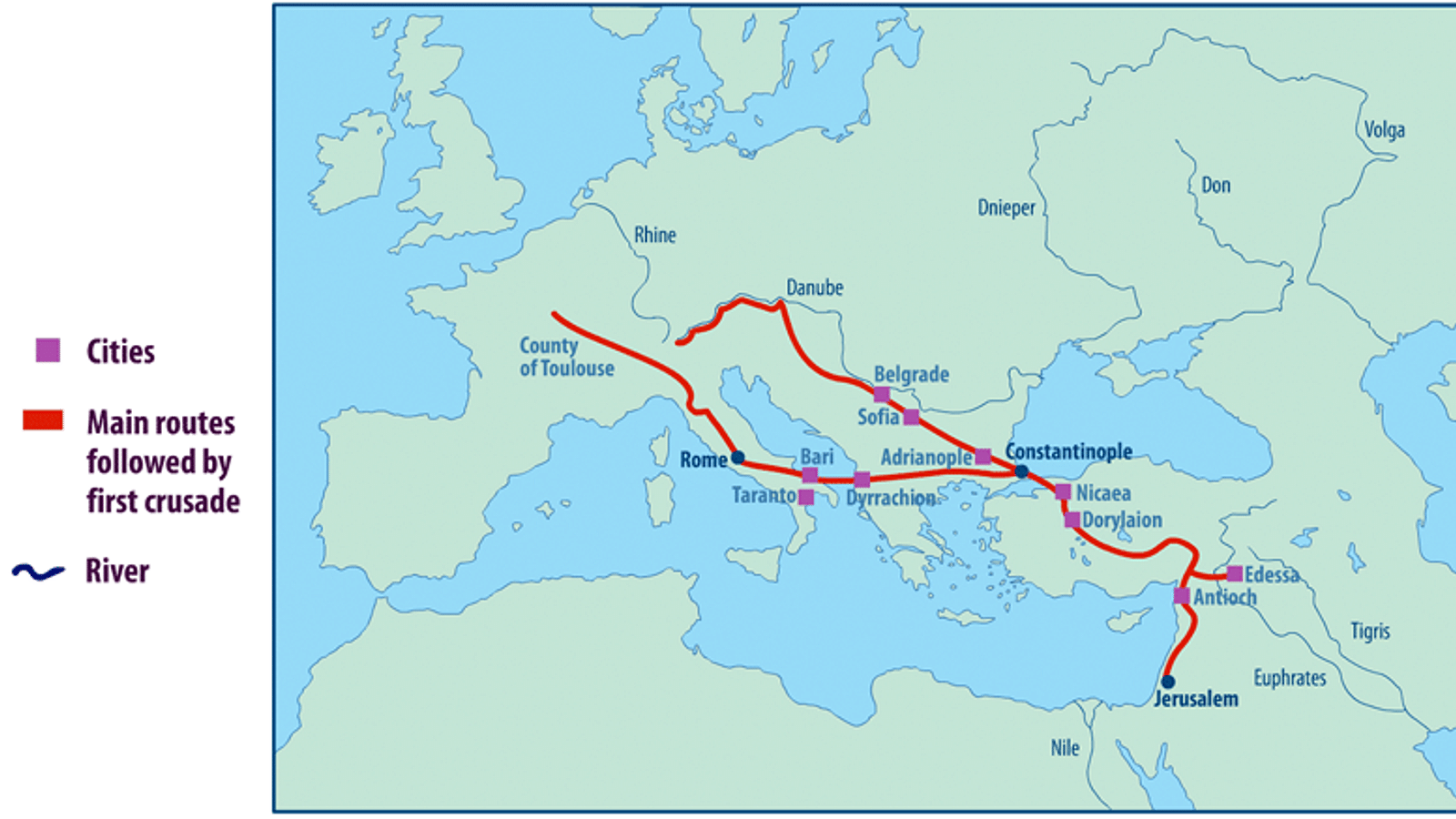
Scrapped that. Decided to take it route by route, step by step, like I originally planned.
- Started small: just the starting points for the different armies. One pin for French nobles gathering in Lyon. Another for the German princes near Regensburg. Another bunch down in Italy. Kept it simple.
- Then, traced the first leg over land. Drew lines connecting the dots across Germany and Hungary towards Constantinople. Used a slightly thicker line for the main "People's Crusade" that kinda went rogue and got smashed early.
- Big pause here. The leaders all hung out near Constantinople for ages bickering. Needed a big obvious pin there. Labeled it clearly.
- Next, crossing into Turkey. First major battle site got its own big red pin - Nicea. Drew the line down along the coast towards Antioch.
- Antioch needed special attention. Such a long siege! Used a special icon for the siege, then a line showing the messy aftermath where they kinda drifted around before marching on Jerusalem.
- Finally, the big push to Jerusalem. Drew that line. Marked the siege with another icon. Showed the final capture.
Where Things Got Annoying (Really Annoying)
This step-by-step thing? Sounds smooth now. It wasn't. The headaches:
- Finding exact paths was guesswork half the time. Chroniclers weren't exactly giving GPS coordinates. Just "they went kinda east". Ended up approximating routes based on rivers and known roads.
- The map tool hated complex lines. Trying to show where armies split and rejoined? Forget it. Lines either merged weirdly or jumped around. Simplified a lot.
- Making it not look like spaghetti near Constantinople and Antioch? Constant battle. Too many pins close together! Had to zoom way in for those areas.
- Getting the dates vaguely right for each step? Spent hours double-checking sources. "Did that siege really start in October or November?" Ugh.
The "Final" Thing (It's Never Really Finished)
After way more coffee than was healthy and muttering at my screen, I hit "save". Had a map showing the key starting points, the main land route to Constantinople, the slog through Anatolia, the massive siege at Antioch, the confusion afterward, and the final path to Jerusalem. Each key spot highlighted. Different colors or lines for different phases. Labeled it all simply.
Is it perfect? Heck no. Real medieval paths were way messier. But does it show the main journey step-by-step better than most confusing maps out there? Yeah, I think so. Lets you follow the whole long, brutal trip. Still, next time I wanna show messy army splits? Might just use a dang pencil and paper!


