Alright folks, today I wanna share how I finally cracked this whole ancient Greek maps thing. Been messing around with different ways 'cause I kept getting lost myself, figuratively and literally on those old drawings! Figured students could use a simpler path too.
The Frustrating Start
So, I just dove in headfirst. Found this super detailed old map online, printed it out huge. Grabbed a dusty book listing all the regions and cities. Sat down with my highlighter, feeling pumped. "Easy," I thought. Man, was I wrong.
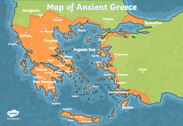
Tried memorizing the shapes first – Attica, Peloponnese, Boeotia. Names swam before my eyes. Names like Pylos, Corinth, Thebes... they all started blending together after five minutes. My brain felt fried. Kept forgetting which peninsula was which. That detailed map? Looked like a plate of spaghetti dropped on the floor. Totally useless for a beginner. Felt like a total failure. Needed a new plan.
Switching Tactics: Keeping it Moving
Decided movement was key. Just staring wasn’t working. Did these three things instead:
- Started Tiny: Ditched the huge map. Found simple outlines – just coastlines and major land chunks like Macedonia or Thessaly. Way less intimidating.
- Got My Hands Dirty: Printed that simple map. Got a blank sheet. Tried drawing it myself. My first try? Looked like a blob monster. Second try? Still blob-ish, but kinda recognizable. Third try? Hey, that actually looks like mainland Greece! Forced me to pay attention to where things curve, where the sea cuts in.
- Played Pin the City: Wrote city names (Athens, Sparta, Delphi) on sticky notes. Stuck them on my drawn map. Moved 'em around till I got it right. Kept mixing up Sparta and Corinth’s location – surprise surprise! Once Sparta stayed put in the south Peloponnese, it kinda clicked.
Weaving Stories into the Land
The real big win? Stopped treating it like geography class. Started thinking about the people and stories. Like:
- Why did Athens become such a big shot sea power? Plopped it near the coast on my map, saw the big sheltered harbour (Piraeus). Made sense! It’s basically the perfect port spot.
- Sparta’s inland location? Looked at my map drawing again. Smack in the middle of a valley – easy to defend, super hard to attack. Explains why they were such tough nuts.
- Ever wondered why Troy mattered so much? Checked where I stuck it: right by this narrow water bit connecting seas (the Dardanelles). Anyone controlling trade there controlled the money flow. Big deal!
Suddenly it wasn't just dots and lines. It was a stage where real history happened.
Tying it All Together (The Fun Part!)
Finally, I tested myself. Took my simple outline map, scattered sticky notes nearby. Covered up my earlier attempts. Tried placing Athens, Sparta, Delphi, Marathon, Troy, Crete back on the map. Not perfect the first time, but way, way better than my initial mess. The process stuck with me.
What students get out of this? For one, it’s active! You’re drawing, placing, moving – way better than zoning out reading. Connecting places to stories or reasons (like harbours, mountains) makes you remember why a place mattered. This helps big time not just for geography, but for understanding history or even those Greek myths better. Plus, figuring out those relationships? That’s critical thinking kicking in! Beats dry memorization any day.
So, yeah. Start simple, grab a pencil, draw badly, tell stories about the land. That’s the ticket to getting those ancient Greek maps into your head without wanting to tear your hair out. Much better!


